Protection Cove
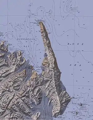
Die Protection Cove (englisch für Schutzbucht) ist eine 5 km breite Bucht an der Pennell-Küste im Norden des ostantarktischen Viktorialands. Sie östlich des Kap Kløvstad am das Kopfende der Robertson Bay westlich der Adare-Halbinsel.
| Protection Cove | ||
|---|---|---|
 Die Protection Cove am Kopfende der Robertson Bay (Mitte links) westlich der Adare-Halbinsel Die Protection Cove am Kopfende der Robertson Bay (Mitte links) westlich der Adare-Halbinsel | ||
| Gewässer | Robertson Bay | |
| Landmasse | Viktorialand, Ostantarktika | |
| Geographische Lage | 71° 39′ 0″ S, 170° 12′ 0″ O | |
| ||
| Breite | 5 km | |
| Zuflüsse | Nameless Glacier, Newnes-Gletscher | |
Teilnehmer der britischen Southern-Cross-Expedition (1898–1900) unter der Leitung des norwegischen Polarforschers Carsten Egeberg Borchgrevink kartierten sie. Borchgrevink benannte sie so, weil das Forschungsschiff Southern Cross hier während eines Sturms Schutz gefunden hatte.
Weblinks
- Protection Cove im Geographic Names Information System des United States Geological Survey (englisch)
- Protection Cove auf geographic.org (englisch)
This article is issued from Wikipedia. The text is licensed under Creative Commons - Attribution - Sharealike. The authors of the article are listed here. Additional terms may apply for the media files, click on images to show image meta data.
