Owambo (Fluss)
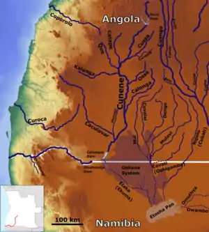
Der Owambo (englisch auch Ovambo) ist ein Omuramba des Flusssystems Omuramba Ovambo[1] im zentralen Norden Namibias. Als Trockenfluss führt er sehr unregelmäßig Wasser, zuletzt 2017.[2] Er ist etwa 150 Kilometer lang.
| Owambo | ||
 Owambo (unten rechts) Owambo (unten rechts) | ||
| Daten | ||
| Lage | Oshikoto, | |
| Flusssystem | Omuramba Ovambo | |
| Quelle | 25 km SO von Tsintsabis 18° 50′ 11″ S, 18° 10′ 39″ O | |
| Mündung | Etosha-Pfanne 18° 44′ 21″ S, 17° 1′ 42″ O
| |
| Länge | 150 km | |
| Einzugsgebiet | 19.426 km² | |
| Linke Nebenflüsse | Nugames | |
| Schiffbar | nein | |
| Omuramba (Trockenfluss) | ||
.jpg.webp) Owambo (2019) Owambo (2019) | ||
Der Owambo, angelehnt an das gleichnamige Volk in dessen Randsiedlungsgebiet er liegt, entspringt etwa 25 Kilometer südöstlich von Tsintsabis, fließt Richtung Westen, passiert Oshivelo im Süden und mündet in die Etosha-Pfanne im Etosha-Nationalpark. Sein Einzugsgebiet umfasst 15.783,756 Quadratkilometer. Er entwässert das Karstveld.[3]
Literatur
- A. Spriggs: Etosha Pan halophytics. WWF, 2001.
- Greg Christelis, Wilhelm Struckmeier: Groundwater in Namibia an explanation to the Hydrogeological Map. Ministry of Agriculture, Water and Rural Development, Januar 2011. (PDF)
Einzelnachweise
- Omuramba-Ovambo, Okavango-South Interior. Riversnetwork. Abgerufen am 18. August 2020.
- Dirk Heinrich: Omuramba Ovambo slowly moves towards Etosha. Gondwana Collection Namibia, 14. März 2017.
- Ben J. Strohbach: Mapping the Major Catchments of Namibia. National Botanical Research Institute, Datum unbekannt, S. 5.
This article is issued from Wikipedia. The text is licensed under Creative Commons - Attribution - Sharealike. The authors of the article are listed here. Additional terms may apply for the media files, click on images to show image meta data.