Nevada State Route 267
Die Nevada State Route 267 (kurz NV 267), auch als Scotty's Castle Road oder Grapevine Canyon Road bekannt, ist eine State Route im US-Bundesstaat Nevada.
| |
|---|---|
| Karte | |
 | |
| Basisdaten | |
| Gesamtlänge: | 21,425 mi/34,48 km |
| Eröffnung: | 1976 |
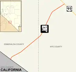
| Anfangspunkt: | North Hwy an der Grenze zu Kalifornien |
| Endpunkt: | |
| Countys: | Nye County Esmeralda County |
_in_Scotty's_Junction%252C_Nevada_copy.jpg.webp)
Nevada State Route 267 in Scotty’s Junction
Die NV 267 beginnt östlich des Scotty's Castles an der Grenze zu Kalifornien am North Highway. Die Strecke verläuft in nordöstlicher Richtung und endet nach 34 Kilometern am U.S. Highway 95 am Scotty’s Junction nordwestlich von Beatty.
Die Straße war zwischen 1942 und 1976 als Nevada State Route 72 bekannt und wurde im Jahr 1952 asphaltiert.
Weblinks
Commons: Nevada State Route 267 – Sammlung von Bildern, Videos und Audiodateien
- Rocky Mountain Roads (englisch)
This article is issued from Wikipedia. The text is licensed under Creative Commons - Attribution - Sharealike. The authors of the article are listed here. Additional terms may apply for the media files, click on images to show image meta data.