Mumienteich
Der Mumienteich (englisch Mummy Pond) ist ein kleiner See im ostantarktischen Viktorialand. Im Taylor Valley liegt er zwischen dem Suess- und dem Lacroix-Gletscher.
| Mumienteich | ||
|---|---|---|
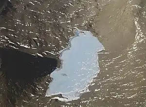 | ||
| Geographische Lage | Taylor Valley, Viktorialand, Ostantarktika | |
| Inseln | wenige (2–3 sichtbar) | |
| Daten | ||
| Koordinaten | 77° 39′ 43″ S, 162° 39′ 41″ O | |
| ||
| Höhe über Meeresspiegel | 155 m | |
| Fläche | 18 ha | |
| Länge | 1 km | |
| Breite | 230 m | |

Der Mumienteich wurde im Dezember 1957 vom US-amerikanischen Geologen Troy L. Péwé (1918–1999) entdeckt und benannt. Namensgebend sind die zahlreichen gefrorenen Robbenkadaver, die Péwé rund um den See vorfand.
Weblinks
- Mummy Pond im Geographic Names Information System des United States Geological Survey (englisch)
- Mummy Pond auf geographic.org (englisch)
This article is issued from Wikipedia. The text is licensed under Creative Commons - Attribution - Sharealike. The authors of the article are listed here. Additional terms may apply for the media files, click on images to show image meta data.