Mount Simpson (Antarktis)
Mount Simpson ist ein Berg auf der Thurston-Insel vor der Eights-Küste des westantarktischen Ellsworthland. In den Walker Mountains ragt er unmittelbar westlich des Kopfendes des Hale-Gletschers auf.
| Mount Simpson | ||
|---|---|---|
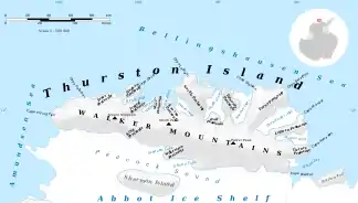
Karte der Thurston-Insel mit Mount Simpson (linke Bildhälfte) | ||
| Lage | Thurston-Insel (Westantarktika) | |
| Gebirge | Walker Mountains | |
| Koordinaten | 72° 8′ 0″ S, 100° 32′ 0″ W | |
| ||

Erstmals kartiert wurde er anhand von Luftaufnahmen der United States Navy bei der Operation Highjump (1946–1947) vom Dezember 1946. Das Advisory Committee on Antarctic Names benannte ihn 1960 nach Leutnant B. L. Simpson Jr. von der Navy-Flugstaffel VX-6, Pilot einer Lockheed P2V Neptune zur Erstellung weiterer Luftaufnahmen von diesem Gebiet im Januar 1960.
Weblinks
- Mount Simpson im Geographic Names Information System des United States Geological Survey (englisch)
- Mount Simpson auf geographic.org (englisch)
This article is issued from Wikipedia. The text is licensed under Creative Commons - Attribution - Sharealike. The authors of the article are listed here. Additional terms may apply for the media files, click on images to show image meta data.