Mount Robinson (Viktorialand)
Mount Robinson ist ein 2430 m hoher Berg im ostantarktischen Viktorialand. In den Admiralitätsbergen ragt er am Kopfende des DeAngelo-Gletschers auf.
| Mount Robinson | ||
|---|---|---|

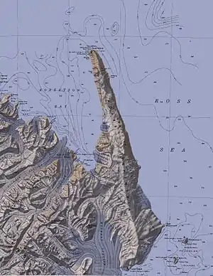
Topografische Karte mit Mount Robinson (links unterhalb der Mitte) | ||
| Höhe | 2430 m | |
| Lage | Viktorialand, Ostantarktika | |
| Gebirge | Admiralitätsberge, Transantarktisches Gebirge | |
| Koordinaten | 71° 50′ 0″ S, 169° 49′ 0″ O | |
| ||
Der britische Polarforscher James Clark Ross entdeckte ihn am 15. Januar 1841 im Verlauf seiner Antarktisexpedition (1839–1843). Ross benannte ihn nach dem britischen Astronomen Thomas Romney Robinson (1792–1882), einem der glühendsten Verfechter geomagnetischer Forschungsarbeiten in der Antarktis und Mitglied der British Association for the Advancement of Science, die Ross’ Forschungsreise unterstützt hatte.
Weblinks
- Mount Robinson im Geographic Names Information System des United States Geological Survey (englisch)
- Mount Robinson auf geographic.org (englisch)
This article is issued from Wikipedia. The text is licensed under Creative Commons - Attribution - Sharealike. The authors of the article are listed here. Additional terms may apply for the media files, click on images to show image meta data.
