Mount Burnham (Viktorialand)
Mount Burnham ist ein markanter, 2810 m hoher Berg in Form einer Klippe im ostantarktischen Viktorialand. Er ragt entlang der Westwand der Daniels Range etwa 10 km südlich des Big Brother Bluff in den Usarp Mountains auf.
| Mount Burnham | ||
|---|---|---|
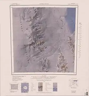
Topographische Karte mit Mount Burnham (Mitte der linken Kartenhälfte) | ||
| Höhe | 2810 m | |
| Lage | Viktorialand, Ostantarktika | |
| Gebirge | Usarp Mountains, Transantarktisches Gebirge | |
| Koordinaten | 71° 33′ 49″ S, 159° 47′ 31″ O | |
| ||
| Normalweg | Hochtour (vergletschert) | |

Kartografisch erfasst wurde er durch Vermessungsarbeiten des United States Geological Survey und mithilfe von Luftaufnahmen der United States Navy zwischen 1960 und 1963. Das Advisory Committee on Antarctic Names benannte ihn 1964 nach James B. Burnham, Ionosphärenphysiker auf der Amundsen-Scott-Südpolstation in den Wintersaisons der Jahre 1958 und 1961. Verwechslungsgefahr besteht mit dem gleichnamigen Berg im antarktischen Marie-Byrd-Land.
Weblinks
- Mount Burnham im Geographic Names Information System des United States Geological Survey (englisch)
- Mount Burnham auf geographic.org (englisch)
This article is issued from Wikipedia. The text is licensed under Creative Commons - Attribution - Sharealike. The authors of the article are listed here. Additional terms may apply for the media files, click on images to show image meta data.