Millerand-Insel
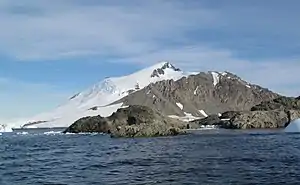
Die Millerand-Insel ist eine schroffe, hoch aufragende Insel von etwa 4,5 km Durchmesser, die rund 6,5 km südlich des Kap Calmette vor der Fallières-Küste des Grahamlands auf der Antarktischen Halbinsel liegt. Sie erreicht eine Höhe von 969 Metern.[1]
| Millerand-Insel | ||
|---|---|---|
 Millerand-Insel | ||
| Gewässer | Marguerite Bay | |
| Geographische Lage | 68° 9′ 0″ S, 67° 13′ 0″ W | |
| ||
| Länge | 6,4 km | |
| Breite | 4,8 km | |
| Höchste Erhebung | 969 m | |
| Einwohner | unbewohnt | |

Entdeckt wurde sie bei der Fünften Französischen Antarktisexpedition (1908–1910) unter der Leitung Jean-Baptiste Charcots, der sie vermutlich nach dem französischen Politiker Alexandre Millerand (1859–1943) benannte.
Weblinks
- Millerand Island im Geographic Names Information System des United States Geological Survey (englisch)
- Millerand Island auf geographic.org (englisch)
Einzelnachweise
This article is issued from Wikipedia. The text is licensed under Creative Commons - Attribution - Sharealike. The authors of the article are listed here. Additional terms may apply for the media files, click on images to show image meta data.