Mavrovouni (Agnanteris-Larisas)
Mavrovouni (Agnanteris-Larisas), (griechisch Μαυροβούνι (n. sg.)) ist ein Berg etwa 32 km süd-östlich von Larisa. Zwei Gipfel steigen auf 725 m (Mavrovouni) bzw. 716 m (Myteri - Μυτερή) an.
| Mavrovouni (Μαυροβούνι) | ||
|---|---|---|
| Höhe | 725 m | |
| Lage | Thessalien | |
| Koordinaten | 39° 26′ 24″ N, 22° 35′ 7″ O | |
| ||
Die umliegenden Dörfer sind: Agnanteris (Αγναντερή) im Osten, Neo Perivoli (Νέον Περιβόλιον) und Kileler im Norden, Myra (Μύρα) und Dilophon (Δίλοφον) im Nordwesten, Skotoussa (Σκοτόυσσα) im Westen und Rigeo (Ρήγαιο) im Süden.
Möglicherweise fand die Schlacht von Kynoskephalai (Μάχη των Κυνός Κεφαλών) in diesem Gebiet statt.
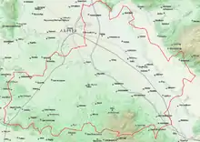
Topografische Karte von Kileler mit dem Berg im Süden
Touristenattraktion ist eine schlammige Thermalquelle.
This article is issued from Wikipedia. The text is licensed under Creative Commons - Attribution - Sharealike. The authors of the article are listed here. Additional terms may apply for the media files, click on images to show image meta data.