Mamalau (Berg)
Der osttimoresische Berg Mamalau (Lolo Mamalau, Manlau) liegt in der Gemeinde Ainaro. Er bildet das Zentrum der Aldeia Mama-Lau (Suco Mau-Nuno, Verwaltungsamt Ainaro). Der Berg hat eine Höhe von 1350 m. Er ist damit der höchste Punkt des Sucos.
| Mamalau | ||
|---|---|---|
| Höhe | 1350 m | |
| Lage | Gemeinde Ainaro, Osttimor | |
| Koordinaten | 9° 1′ 14″ S, 125° 27′ 44″ O | |
| ||
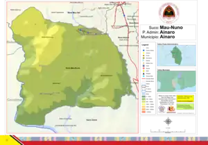
Der Suco Mau-Nuno mit der der Aldeia Mama-Lau im Nordwesten und dem Berg in deren Zentrum | ||
This article is issued from Wikipedia. The text is licensed under Creative Commons - Attribution - Sharealike. The authors of the article are listed here. Additional terms may apply for the media files, click on images to show image meta data.