Liste der Wahlkreise in Botswana
Der folgende Artikel enthält eine Liste der Wahlkreise in Botswana.
Hintergrund
| Wahljahr | Wahlkreise |
|---|---|
| 1965† | 31 |
| 1969 | 31 |
| 1974 | 32 |
| 1979 | 32 |
| 1984 | 34 |
| 1989 | 34 |
| 1994 | 40 |
| 1999 | 40 |
| 2004 | 57 |
| 2009 | 57 |
| 2014 | 57 |
| 2019 | 57 |
| † damals noch Betschuanaland | |
Botswana wurde 1966 vom Vereinigten Königreich unabhängig. Die im selben Jahr in Kraft getretene Verfassung Botswanas sieht vor (Artikel 64), dass die Grenzen der Wahlkreise durch eine Abgrenzungskommission (Delimitation Commission) festgelegt werden sollen. Die Kommission soll dabei mindestens alle 10 Jahre und höchstens alle 5 Jahre mit der Neufestsetzung der Wahlkreisgrenzen beauftragt werden bzw. immer dann, wenn eine neue Volkszählung erfolgt ist oder das Parlament eine Veränderung der Zahl seiner Abgeordneten beschlossen hat. Jeder Wahlkreis soll dabei in etwa dieselbe Bevölkerungszahl enthalten.[2] Dies geschah in regelmäßigen Abständen und die Zahl der Wahlkreise vermehrte sich parallel zum allgemeinen Bevölkerungswachstum von anfänglich 31 auf zuletzt (Stand 2019) 57. Die letzte Anpassung fand im Jahr 2013 statt. Dabei wurde die Zahl der Wahlkreise unverändert gelassen, jedoch deren Zuschnitt teilweise angepasst.[3]
Liste der Wahlkreise
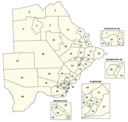
Die Nummerierung der Wahlkreise entspricht der offiziellen Nummerierung und der der nebenstehenden Karte.
| Nr. | Name | Bevölkerung (2012) |
Fläche (km²) |
Distrikt |
|---|---|---|---|---|
| 1 | Chobe | 23.347 | 21.044 | North-West District |
| 2 | Maun East | 43.174 | 27.940 | North-West District |
| 3 | Maun West | 40.506 | 9.532 | North-West District |
| 4 | Ngami | 34.387 | 41.779 | North-West District |
| 5 | Okavango | 34.217 | 32.095 | North-West District |
| 6 | Tati East | 30.881 | 3.021 | North-East District |
| 7 | Tati West | 29.383 | 2.110 | North-East District |
| 8 | Francistown East | 32.700 | 47 | North-East District |
| 9 | Francistown West | 33.133 | 20 | North-East District |
| 10 | Francistown South | 33.128 | 133 | North-East District |
| 11 | Nata-Gweta | 31.533 | 31.162 | Central District |
| 12 | Nkange | 42.402 | 4.129 | Central District |
| 13 | Shashe West | 37.032 | 3.815 | Central District |
| 14 | Tonota | 39.189 | 5.389 | Central District |
| 15 | Bobonong | 42.472 | 8.811 | Central District |
| 16 | Mmadinare | 38.436 | 9.374 | Central District |
| 17 | Selebi Phikwe East | 24.652 | 53 | Central District |
| 18 | Selebi Phikwe West | 24.759 | 89 | Central District |
| 19 | Lerala-Maunalala | 33.743 | 3.228 | Central District |
| 20 | Palapye | 40.691 | 978 | Central District |
| 21 | Sefhare-Ramokgonami | 31.517 | 4.361 | Central District |
| 22 | Mahalapye East | 25.835 | 5.031 | Central District |
| 23 | Mahalapye West | 32.896 | 488 | Central District |
| 24 | Shoshong | 29.147 | 10.580 | Central District |
| 25 | Serowe North | 33.404 | 4.608 | Central District |
| 26 | Serowe West | 25.572 | 15.605 | Central District |
| 27 | Serowe South | 35.400 | 3.146 | Central District |
| 28 | Boteti East | 37.534 | 16.538 | Central District |
| 29 | Boteti West | 32.390 | 19.290 | Central District |
| 30 | Mochudi East | 44.197 | 3.823 | Kgatleng District |
| 31 | Mochudi West | 47.463 | 3.796 | Kgatleng District |
| 32 | Gaborone Central | 47.277 | 20 | South-East District |
| 33 | Gaborone North | 46.434 | 96 | South-East District |
| 34 | Gaborone South | 45.230 | 44 | South-East District |
| 35 | Gaborone Bonnington North | 45.688 | 23 | South-East District |
| 36 | Gaborone Bonnington South | 46.963 | 13 | South-East District |
| 37 | Tlokweng | 36.054 | 400 | South-East District |
| 38 | Ramotswa | 47.237 | 637 | South-East District |
| 39 | Mogoditshane | 47.206 | 31 | Kweneng District |
| 40 | Gabane-Mmankgodi | 48.287 | 339 | Kweneng District |
| 41 | Thamaga-Kumakwane | 36.402 | 1.157 | Kweneng District |
| 42 | Molepolole North | 34.947 | 178 | Kweneng District |
| 43 | Molepolole South | 36.714 | 327 | Kweneng District |
| 44 | Lentswaeletau-Mmopane | 42.633 | 3.061 | Kweneng District |
| 45 | Letlhakeng-Lephephe | 34.464 | 10.439 | Kweneng District |
| 46 | Takatokwane | 23.896 | 21.435 | Kweneng District |
| 47 | Lobatse | 30.730 | 520 | South-East District |
| 48 | Goodhope-Mabule | 34.079 | 2.735 | Southern District |
| 49 | Mmathethe-Molapowabojang | 39.989 | 8.328 | Southern District |
| 50 | Kanye North | 34.181 | 864 | Southern District |
| 51 | Kanye South | 36.647 | 1.478 | Southern District |
| 52 | Moshupa-Manyana | 32.544 | 2.062 | Southern District |
| 53 | Jwaneng-Mabutsane | 38.335 | 11.866 | Southern District |
| 54 | Kgalagadi North | 18.092 | 44.887 | Kgalagadi District |
| 55 | Kgalagadi South | 32.400 | 60.029 | Kgalagadi District |
| 56 | Ghanzi North | 23.101 | 72.580 | Ghanzi District |
| 57 | Ghanzi South | 20.254 | 42.295 | Ghanzi District |
Einzelnachweise
- Election Passport. electionpassport.com, abgerufen am 26. Oktober 2019 (englisch).
- Constitution of Botswana. (pdf) Webseite des Parlaments von Botswana, abgerufen am 26. Oktober 2019 (englisch).
- Report on the Delimitation Commission, 2012. (pdf) 11. Februar 2013, abgerufen am 26. Oktober 2019 (englisch).
- Republic of Botswana Constituency Plan Appendix A. (pdf) Februar 2013, abgerufen am 26. Oktober 2019 (englisch).