Hunt Bluff
Das Hunt Bluff ist ein steiles und 5 km langes Felsenkliff an der Walgreen-Küste des westantarktischen Marie-Byrd-Lands. Es ragt 3 km südlich des Jeffery Head an der Westseite der Bear-Halbinsel auf und grenzt unmittelbar an das Dotson-Schelfeis.
| Hunt Bluff | ||
|---|---|---|
| Lage | Marie-Byrd-Land, Westantarktika | |
| ||
| Koordinaten | 74° 36′ S, 111° 52′ W | |
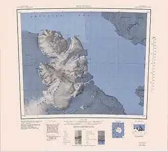 Karte der Bear-Halbinsel mit dem Hunt Bluff (links) Karte der Bear-Halbinsel mit dem Hunt Bluff (links) | ||

Erste Luftaufnahmen entstanden bei der US-amerikanischen Operation Highjump (1946–1947). Das Advisory Committee on Antarctic Names benannte es 1967 nach Leutnant Robert Bridger Hunt (1940–2004) von der United States Navy Reserve, medizinischer Offizier auf der Byrd-Station im antarktischen Winter 1966.
Weblinks
- Hunt Bluff im Geographic Names Information System des United States Geological Survey (englisch)
- Hunt Bluff auf geographic.org (englisch)
This article is issued from Wikipedia. The text is licensed under Creative Commons - Attribution - Sharealike. The authors of the article are listed here. Additional terms may apply for the media files, click on images to show image meta data.