Herzog-von-York-Insel
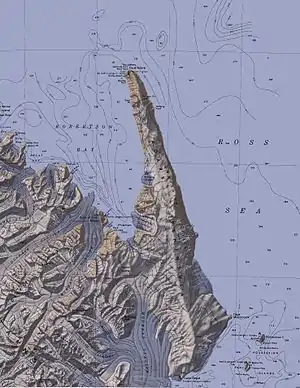
Die Herzog-von-York-Insel (englisch Duke of York Island) ist eine bergige, eisfreie, 4 km lange und bis zu 555 m hohe Insel vor der Pennell-Küste des ostantarktischen Viktorialands. Sie liegt südlichen Teil der Robertson Bay.
| Herzog-von-York-Insel | ||
|---|---|---|
 Herzog-von-York-Insel im Südwesten der Robertson Bay (Mitte links) | ||
| Gewässer | Robertson Bay, Somow-See | |
| Geographische Lage | 71° 38′ 0″ S, 170° 4′ 0″ O | |
| ||
| Länge | 4 km | |
| Höchste Erhebung | 555 m | |
| Einwohner | unbewohnt | |
Erstmals kartiert wurde sie bei der britischen Southern-Cross-Expedition (1898–1900) unter der Leitung des norwegischen Polarforschers Carsten Egeberg Borchgrevink. Borchgrevink benannte sie nach Georg, Prince of Wales, 1. Duke of York (1865–1936), dem späteren britischen König Georg V.
Weblinks
- Duke of York Island im Geographic Names Information System des United States Geological Survey (englisch)
- Duke of York Island auf geographic.org (englisch)
This article is issued from Wikipedia. The text is licensed under Creative Commons - Attribution - Sharealike. The authors of the article are listed here. Additional terms may apply for the media files, click on images to show image meta data.
