Goroubi
Der Goroubi ist ein saisonaler rechter Nebenfluss des Niger in Burkina Faso und Niger.
| Goroubi | ||
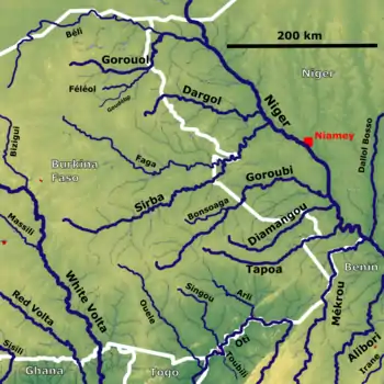
 Die westlichen Niger-Zuflüsse im Niger mit dem Goroubi (mitte rechts) Die westlichen Niger-Zuflüsse im Niger mit dem Goroubi (mitte rechts) | ||
| Daten | ||
| Lage | ||
| Flusssystem | Niger | |
| Abfluss über | Niger → Golf von Guinea | |
| Quelle | in Burkina Faso | |
| Mündung | in den Niger 12° 54′ 2″ N, 2° 22′ 42″ O | |
| Mündungshöhe | 176 m
| |
| Länge | 433 km[1] | |
| Einzugsgebiet | 15.500 km²[1] | |
| Abfluss am Pegel Diongore[1] AEo: 15.350 km² Lage: 15 km oberhalb der Mündung |
MNQ 1962–1967 MQ 1962–1967 Mq 1962–1967 MHQ 1962–1967 HHQ (17.9.1962) |
0 l/s 7,8 m³/s 0,5 l/(s km²) 44,1 m³/s 150 m³/s |
Verlauf
Der Fluss entspringt in der Nord-Osten Burkina Fasos. Er fließt in östliche Richtung. Der Goroubi mündet im Niger von rechts in den Fluss Niger.
Hydrometrie
Durchschnittliche monatliche Durchströmung des Goroubi an der hydrologischen Station Diongore, 15 km vor der Mündung, gemessen in m³/s.[1]
Einzelnachweise
This article is issued from Wikipedia. The text is licensed under Creative Commons - Attribution - Sharealike. The authors of the article are listed here. Additional terms may apply for the media files, click on images to show image meta data.