Glacier Bight
Die Glacier Bight ist eine 35 km breite und schiffbare Bucht im Norden der Thurston-Insel vor der Eights-Küste des westantarktischen Ellsworthlands. Sie liegt zwischen der Hughes- und der Noville-Halbinsel.
| Glacier Bight | ||
|---|---|---|
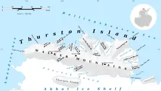 Karte der Thurston-Insel mit der Hughes- und der Noville-Halbinsel (Mitte links) Karte der Thurston-Insel mit der Hughes- und der Noville-Halbinsel (Mitte links) | ||
| Gewässer | Bellingshausen-See | |
| Landmasse | Thurston-Insel, Westantarktika | |
| Geographische Lage | 71° 50′ S, 99° 25′ W | |
| ||
| Breite | 35 km | |

Ihre Position wurde erstmals anhand von Luftaufnahmen der United States Navy während der Operation Highjump (1946–1947) bestimmt. Das Advisory Committee on Antarctic Names benannte sie nach dem Eisbrecher USS Glacier, mit dem im Februar 1960 erstmals die Annäherung an diese Küstenregion der Thurston-Insel gelang.
Weblinks
- Glacier Bight im Geographic Names Information System des United States Geological Survey (englisch)
- Glacier Bight auf geographic.org (englisch)
This article is issued from Wikipedia. The text is licensed under Creative Commons - Attribution - Sharealike. The authors of the article are listed here. Additional terms may apply for the media files, click on images to show image meta data.