Ghorband
Der Ghorband ist ein rechter Nebenfluss des Pandschschir im Osten Afghanistans.
| Ghorband | ||
 Der Ghorband (links im Bild) verlässt das Bergland bei Pule Matak Der Ghorband (links im Bild) verlässt das Bergland bei Pule Matak | ||
| Daten | ||
| Lage | Parwan (Afghanistan) | |
| Flusssystem | Indus | |
| Abfluss über | Pandschschir → Kabul → Indus → Indischer Ozean | |
| Quelle | im Nordwesten der Provinz Parwan 35° 0′ 58″ N, 68° 11′ 47″ O | |
| Quellhöhe | ca. 4400 m | |
| Mündung | Fluss Pandschschir 34° 59′ 59″ N, 69° 18′ 27″ O
| |
| Länge | ca. 130 km | |
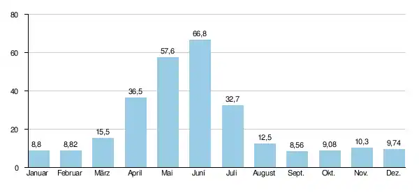
| Abfluss am Pegel Pul-i-Ashwawa[1] AEo: 4020 km² |
MQ 1959/1980 Mq 1959/1980 |
23,1 m³/s 5,7 l/(s km²) |
| Linke Nebenflüsse | Salang | |
| Rechte Nebenflüsse | Turkman | |
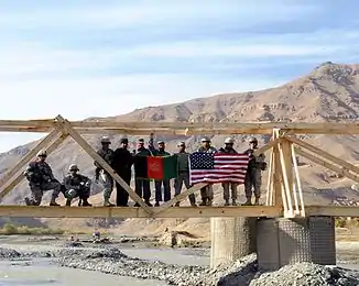 Von US-Soldaten gebaute Brücke im Bezirk Ghorband, Provinz Parwan Von US-Soldaten gebaute Brücke im Bezirk Ghorband, Provinz Parwan | ||
Verlauf
Vom äußersten Nordwesten der Provinz Parwan kommend, durchfließt der Ghorband die Provinz ostwärts, um an der Provinzgrenze, nahe der Stadt Tscharikar, in den Fluss Pandschschir zu münden. Der Ghorband formte das vielleicht 500 m breite und mehrere hundert Meter in das umgebende Gebirge des Hindukusch eingeschnittene Parwan-Tal, wo auch die Straße A77 verläuft.
Hydrometrie
Mittlerer monatlicher Abfluss des Ghorband (in m³/s) am Pegel Pul-i-Ashwawa
gemessen von 1959 bis 1980[1]
Weblinks
Commons: Ghorband – Sammlung von Bildern, Videos und Audiodateien
- Karte der Provinz Parwan (PDF; 284 kB)
Einzelnachweise
This article is issued from Wikipedia. The text is licensed under Creative Commons - Attribution - Sharealike. The authors of the article are listed here. Additional terms may apply for the media files, click on images to show image meta data.