East Arm
Der East Arm ist eine felsige Landspitze an der Mawson-Küste des ostantarktischen Mac-Robertson-Lands. In der Holme Bay stellt sie die östliche Begrenzung des Horseshoe Harbour dar.
| East Arm | ||
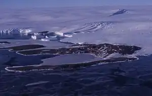 Luftbild vom Horseshoe Harbour, der vom East Arm und West Arm eingefasst wird | ||
| Geographische Lage | ||
| ||
| Koordinaten | 67° 36′ S, 62° 52′ O | |
| Lage | Mac-Robertson-Land, Ostantarktika | |
| Küste | Mawson-Küste | |
| Gewässer | Holme Bay | |
| Gewässer 2 | Horseshoe Harbour | |

Norwegische Kartografen kartierten sie grob anhand von Luftaufnahmen, die bei der Lars-Christensen-Expedition 1936/37 entstanden. Weitere Luftaufnahmen wurden bei der US-amerikanischen Operation Highjump erstellt. Eine Mannschaft um den australischen Polarforscher Phillip Law, der die Landspitze deskriptiv nach ihrer geografischen Lage benannte, besuchte sie am 5. Februar 1954.
Weblinks
- East Arm im Geographic Names Information System des United States Geological Survey (englisch)
- East Arm auf geographic.org (englisch)
- East Arm im Composite Gazetteer of Antarctica (englisch)
This article is issued from Wikipedia. The text is licensed under Creative Commons - Attribution - Sharealike. The authors of the article are listed here. Additional terms may apply for the media files, click on images to show image meta data.