Dyer Island (Rhode Island)
Dyer Island ist eine kleine Insel in der Narragansett Bay im US-Bundesstaat Rhode Island.
| Dyer Island | ||
|---|---|---|
| Gewässer | Narragansett Bay, Atlantischer Ozean | |
| Geographische Lage | 41° 34′ 57″ N, 71° 17′ 58″ W | |
| ||
| Länge | 600 m | |
| Breite | 200 m | |
| Fläche | 12 ha | |
| Einwohner | unbewohnt | |
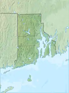
Sie liegt einen Kilometer vor der Westküste der Insel Rhode Island und ist Teil des Ortes Melville, welcher zur Stadt Portsmouth gehört.
Dyer Island ist unbewohnt und hat eine Landfläche von etwa 12 Hektar. 1300 Meter westlich liegt Prudence Island.
Weblinks
- Dyer Island im Geographic Names Information System des United States Geological Survey
- Dyer Island: Block 9021, Census Tract 401.03, Newport County, Rhode Island United States Census Bureau
This article is issued from Wikipedia. The text is licensed under Creative Commons - Attribution - Sharealike. The authors of the article are listed here. Additional terms may apply for the media files, click on images to show image meta data.