Desolation Island (Südliche Shetlandinseln)
Desolation Island (von englisch desolation ‚Trostlosigkeit, Ödnis‘, in Chile Isla Desolación) ist eine v-förmige Insel im Archipel der Südlichen Shetlandinseln. Sie liegt im Osten der Einfahrt der Hero Bay vor der Nordküste der Livingston-Insel in einer Entfernung von 8 km westlich zum Williams Point.
| Desolation Island | ||
|---|---|---|
 Blick von den Vidin Heights auf Desolation Island (Mitte) mit den Miladinovi Islets (links) und Wood Island (links vorne) | ||
| Gewässer | Hero Bay, Drakestraße | |
| Inselgruppe | Südlichen Shetlandinseln | |
| Geographische Lage | 62° 27′ S, 60° 21′ W | |
| ||
| Höchste Erhebung | Burel Hill 152 m | |
| Einwohner | unbewohnt | |
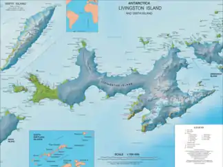 Karte der Livingston-Insel mit Desolation Island in der Hero Bay | ||

Entdeckt wurde sie 1820 vom britischen Seefahrer Edward Bransfield, der sie nach dem trostlosen Eindruck benannte, den die Insel auf ihn machte.
Weblinks
- Desolation Island im Geographic Names Information System des United States Geological Survey (englisch)
- Desolation Island auf geographic.org (englisch)
This article is issued from Wikipedia. The text is licensed under Creative Commons - Attribution - Sharealike. The authors of the article are listed here. Additional terms may apply for the media files, click on images to show image meta data.