Dargle
Der Fluss Dargle (irisch: An Deargail, dt. „kleiner roter Punkt“) entspringt in den Wicklow Mountains Irlands am Nordhang des Djouce Mountain. Er speist den mit 112 m höchsten Wasserfall Irlands, den Powerscourt-Waterfall (Eas Chúirt an Phaoraigh) und fließt durch das Glencree-Tal (Gleann Crí), wo er sich mit dem Fluss Glencree vereinigt. 14 km weiter östlich mündet er bei Bray in die irische See.
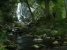
Dargle Wasserfall
| Dargle An Deargail | ||
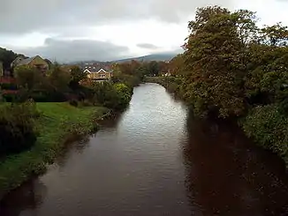 River Dargle in Bray, County Wicklow River Dargle in Bray, County Wicklow | ||
| Daten | ||
| Lage | Irland | |
| Flusssystem | Dargle | |
| Quelle | Wicklow Mountains | |
| Mündung | Irische See bei Bray 53° 12′ 31″ N, 6° 6′ 9″ W | |
Weblinks
Commons: River Dargle – Sammlung von Bildern, Videos und Audiodateien
This article is issued from Wikipedia. The text is licensed under Creative Commons - Attribution - Sharealike. The authors of the article are listed here. Additional terms may apply for the media files, click on images to show image meta data.