Colorado State Highway 391
Colorado State Route 391 ist ein in Nord-Süd-Richtung verlaufender Highway im US-Bundesstaat Colorado.
| |
|---|---|
| Karte | |
 | |
| Basisdaten | |
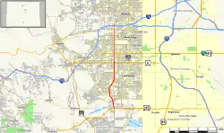
| Gesamtlänge: | 9,1 Meilen / 15,3 Kilometer |
| Anfangspunkt: | |
| Endpunkt: | |
| County: | Jefferson County |
Der Highway beginnt am U.S. Highway 285 in Lakewood und endet in Wheat Ridge an der Interstate 70. Von dem US 285 bis zur West Mississippi Avenue ist die State Route als Kipling Parkway und von dort bis zur I-70 als Kipling Street bekannt.
Weblinks
Commons: Colorado State Highway 391 – Sammlung von Bildern, Videos und Audiodateien
This article is issued from Wikipedia. The text is licensed under Creative Commons - Attribution - Sharealike. The authors of the article are listed here. Additional terms may apply for the media files, click on images to show image meta data.