Colorado State Highway 17
Der Colorado State Highway 17 (kurz CO 17) ist ein in Nord-Süd-Richtung verlaufender State Highway im US-Bundesstaat Colorado.

| |
|---|---|
| Karte | |
 | |
| Basisdaten | |
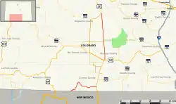
| Gesamtlänge: | 88 Meilen / 142 Kilometer |
| Anfangspunkt: | |
| Endpunkt: | |
| Countys: | Archuleta County Conejos County Alamosa County Saguache County |
Der State Highway besteht aus zwei getrennten Abschnitten, die mit dem U.S. Highway 285 verbunden sind. Die erste Abschnitt beginnt an der Grenze zu New Mexico an der New Mexico State Route 17 und endet am U.S. Highway 285 in Antonito. Das zweite Teilstück verläuft parallel zum US 285 zwischen Alamosa und Villa Grove. In Alamosa zweigt außerdem der U.S. Highway 160 ab und in Hooper beginnt der Colorado State Highway 112.
Weblinks
Commons: Colorado State Highway 17 – Sammlung von Bildern, Videos und Audiodateien
This article is issued from Wikipedia. The text is licensed under Creative Commons - Attribution - Sharealike. The authors of the article are listed here. Additional terms may apply for the media files, click on images to show image meta data.