Colorado State Highway 131
Der Colorado State Highway 131 ist ein in Nord-Süd-Richtung verlaufender Highway im US-Bundesstaat Colorado.
| |
|---|---|
| Karte | |
 | |
| Basisdaten | |
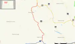
| Gesamtlänge: | 68,7 Meilen / 110,6 Kilometer |
| Anfangspunkt: | |
| Endpunkt: | |
| Countys: | Routt County Eagle County |
Der Highway beginnt am U.S. Highway 40 südlich von Steamboat Springs und endet nahe Wolcott an der Interstate 70.
Der State Highway führt durch die Orte State Bridge, Bond, McCoy, Toponas, Yampa und Oak Creek.
Weblinks
Commons: Colorado State Highway 131 – Sammlung von Bildern, Videos und Audiodateien
This article is issued from Wikipedia. The text is licensed under Creative Commons - Attribution - Sharealike. The authors of the article are listed here. Additional terms may apply for the media files, click on images to show image meta data.