Cannonball River
Der Cannonball River[1] ist ein 217 Kilometer langer Zufluss des Missouri River im Südwesten des US-Bundesstaates North Dakota.
| Cannonball River | ||
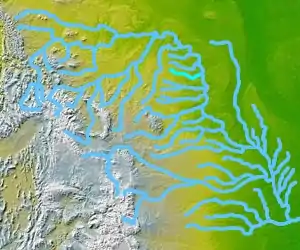 Flusssystem des Missouri, türkis: Cannonball River Flusssystem des Missouri, türkis: Cannonball River | ||
| Daten | ||
| Gewässerkennzahl | US: 1035898 | |
| Lage | North Dakota, USA | |
| Flusssystem | Mississippi River | |
| Abfluss über | Missouri → Mississippi → Golf von Mexiko | |
| Quelle | im Little Missouri National Grassland 46° 28′ 12″ N, 103° 12′ 24″ W | |
| Mündung | nahe Cannon Ball in den Lake Oahe 46° 25′ 45″ N, 100° 35′ 21″ W | |
| Mündungshöhe | 491 m[1]
| |
| Länge | 217 km | |
 Cannonball River North Dakota Cannonball River North Dakota | ||
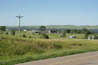
Er entspringt im Little Missouri National Grassland, in den Badlands nördlich von Amidon im Slope County. Er fließt in ostsüdöstlicher Richtung an New England, Mott und Burt vorbei. Etwa 24 Kilometer südwestlich von Shields mündet der Cedar Creek ein. Sein Kurs ändert sich dann in eine nordöstliche Richtung und der Fluss bildet dann die nördliche Grenze des Sioux County und der Standing Rock Reservation bzw. die südliche Grenze von Grant County und Morten County. Der Cannonball River mündet in den Missouri im Lake Oahe in der Nähe von Cannon Ball. Der Name Cannonball, auf Deutsch Kanonenkugel kommt von den großen runden Steinen, die man an der Mündung in den Missouri finden konnte. Die ersten weißen Besucher hielten sie für Kanonenkugeln. Heute sind die Steine nicht mehr sichtbar, da der Stausee die Mündung des Flusses überflutet hat.[2][3] Internationale Bekanntheit bekam der Cannonball River durch die Proteste der Sioux-Ureinwohner gegen ein geplantes Pipeline-Projekt, welches den Fluss unterqueren soll. Die Reservats-Regierung von Standing-Rock und der Stamm sind führend bei Protesten gegen eine Pipeline, die in der Nähe des Cannonball unter dem Missouri hindurch geführt werden soll. Auch beklagt der Stamm, dass die Bauarbeiten wichtige Grabstätten der Sioux zerstört hätten. Die Sioux befürchten, dass die von der Firma 'Energy Transfer Plants' geplante Pipeline im Falle eines Rohrbruchs das Wasser des Reservats verunreinigen und das Reservat unbewohnbar machen könnte. Nach Angaben der Reservats-Regierung führt das Pipeline-Projekt nur 500 Meter an der Reservats-Grenze vorbei.[4]
Siehe auch
Belege
- Cannonball River (Englisch) In: Geographic Names Information System. United States Geological Survey. Abgerufen am 30. April 2016.
- Standing Rock protests: this is only the beginning The Cannonball river used to meet the Missouri in such a way that their turbulent waters turned out big round stones – which white people saw as cannonballs, thus the name – but now the smaller river sinks quietly into the lake, and the stones are gone and so are the forces that made them.
- www.prairiepublic.org The Cannonball River was, of course, named after the interesting cannonball-like concretions that may be found along the river.
- Spiegel Online Gewaltsamer Protest gegen Pipeline