California State Route 94
California State Route 94, kurz CA 94, ist ein Highway im US-Bundesstaat Kalifornien, der in Ost-West-Richtung verläuft.
| |||||||||||||||||||||||||||||||||||||||||||||||||||||||||||||
|---|---|---|---|---|---|---|---|---|---|---|---|---|---|---|---|---|---|---|---|---|---|---|---|---|---|---|---|---|---|---|---|---|---|---|---|---|---|---|---|---|---|---|---|---|---|---|---|---|---|---|---|---|---|---|---|---|---|---|---|---|---|
| Karte | |||||||||||||||||||||||||||||||||||||||||||||||||||||||||||||
 | |||||||||||||||||||||||||||||||||||||||||||||||||||||||||||||
| Basisdaten | |||||||||||||||||||||||||||||||||||||||||||||||||||||||||||||
| Gesamtlänge: | 65,39 mi/105,24 km | ||||||||||||||||||||||||||||||||||||||||||||||||||||||||||||
| Anfangspunkt: | |||||||||||||||||||||||||||||||||||||||||||||||||||||||||||||
| Endpunkt: | |||||||||||||||||||||||||||||||||||||||||||||||||||||||||||||
| County: | San Diego County | ||||||||||||||||||||||||||||||||||||||||||||||||||||||||||||
| Wichtige Städte: | Lemon Grove La Mesa | ||||||||||||||||||||||||||||||||||||||||||||||||||||||||||||
|
Verlauf
| |||||||||||||||||||||||||||||||||||||||||||||||||||||||||||||
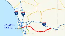
Der Highway beginnt an der Interstate 5 in San Diego und endet in Manzanita an der Interstate 8. Die State Route nähert sich der mexikanischen Grenze bis auf eine halbe Meile, etwa 900 Meter. Auf der Hälfte der Strecke führt die California State Route 188 bis zum mexikanischen Ort Tecate.
Weblinks
- California @ AARoads Streckenbeschreibung mit Fotos (englisch)
- California Highways (englisch)
This article is issued from Wikipedia. The text is licensed under Creative Commons - Attribution - Sharealike. The authors of the article are listed here. Additional terms may apply for the media files, click on images to show image meta data.