California State Route 86
Die California State Route 86 (kurz CA 86) ist eine State Route im US-Bundesstaat Kalifornien, die in Nord-Süd-Richtung verläuft.
| |
|---|---|
| Karte | |
 | |
| Basisdaten | |
| Gesamtlänge: | 91 mi/145 km |
| Eröffnung: | 1964 |
| Anfangspunkt: | |
| Endpunkt: | |
| Countys: | Imperial County Riverside County |
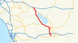
Die State Route beginnt an der California State Route 111 nahe Indio und endet bei Calexico nahe der mexikanischen Grenze wieder an der CA 111. Die State Route verläuft nach dem Kreuz mit der Interstate 8 zuerst durch das Imperial Valley, anschließend im Gegensatz zur CA 111 westlich am Saltonsee vorbei und danach durch das Coachella Valley.
Über die bei Oasis beginnende Umgehungsstraße California State Route 86S ist die CA 86 indirekt mit der Interstate 10 verbunden.
Weblinks
Commons: California State Route 86 – Sammlung von Bildern, Videos und Audiodateien
- California Highways
- California @ AA Roads Streckenbeschreibung mit Fotos (englisch)
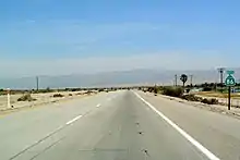
California State Route beim Saltonsee
This article is issued from Wikipedia. The text is licensed under Creative Commons - Attribution - Sharealike. The authors of the article are listed here. Additional terms may apply for the media files, click on images to show image meta data.