California State Route 7
Die California State Route 7 (kurz CA 7) ist eine State Route im US-Bundesstaat Kalifornien, die in Nord-Süd-Richtung verläuft.
| |||||||||||||
|---|---|---|---|---|---|---|---|---|---|---|---|---|---|
| Karte | |||||||||||||
 | |||||||||||||
| Basisdaten | |||||||||||||
| Gesamtlänge: | 7 mi/11,27 km | ||||||||||||
| Eröffnung: | 1990 | ||||||||||||
| Anfangspunkt: | Mexikanische Grenze in Calexico | ||||||||||||
| Endpunkt: | |||||||||||||
| County: | Imperial County | ||||||||||||
|
Verlauf
| |||||||||||||
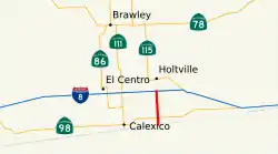
Der Highway beginnt an der Mexikanischen Grenze in Calexico und endet in El Centro an der Interstate 8 und an der Imperial County Route S32. Der State Highway wurde im Jahr 1990 eröffnet. Der Abschnitt zwischen der California State Route 98 und der I-8 wurde erst 2005 fertiggestellt.
Weblinks
- California @ AA Roads Streckenbeschreibung mit Fotos (englisch)
- California Highways (englisch)
This article is issued from Wikipedia. The text is licensed under Creative Commons - Attribution - Sharealike. The authors of the article are listed here. Additional terms may apply for the media files, click on images to show image meta data.