California State Route 56
Die California State Route 56 (kurz CA 56) ist eine State Route im US-Bundesstaat Kalifornien, die in Nord-Süd-Richtung verläuft.
| |||||||||||||||||||
|---|---|---|---|---|---|---|---|---|---|---|---|---|---|---|---|---|---|---|---|
| Karte | |||||||||||||||||||
 | |||||||||||||||||||
| Basisdaten | |||||||||||||||||||
| Gesamtlänge: | 16 mi/25 km | ||||||||||||||||||
| Anfangspunkt: | |||||||||||||||||||
| Endpunkt: | |||||||||||||||||||
| County: | San Diego County | ||||||||||||||||||
| Wichtige Stadt: | San Diego | ||||||||||||||||||
|
Verlauf
| |||||||||||||||||||
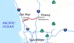
Die State Route beginnt an der Interstate 5 in Carmel Valley und endet in Rancho Peñasquitos an der Interstate 15. Bei den ersten Planungen zur CA 56 sollte sie weiter in Richtung Osten bis zur California State Route 67 gebaut werden. Dies wurde aber später wieder verworfen.
Die CA 56 wird oft Ted Williams Freeway genannt, um den in San Diego geborenen Baseballspieler Ted Williams zu würdigen.
Weblinks
Commons: California State Route 56 – Sammlung von Bildern, Videos und Audiodateien
- California @ AA Roads Streckenbeschreibung mit Fotos (englisch)
- California Highways (englisch)
This article is issued from Wikipedia. The text is licensed under Creative Commons - Attribution - Sharealike. The authors of the article are listed here. Additional terms may apply for the media files, click on images to show image meta data.