California State Route 209
Die California State Route 209 (kurz CA 209) war eine State Route im US-Bundesstaat Kalifornien, die in Nord-Süd-Richtung verlief.

| |
|---|---|
| Karte | |
 | |
| Basisdaten | |
| Gesamtlänge: | 8 mi/13 km |
| Eröffnung: | 1963 |
| Auflösung: | 2003 |
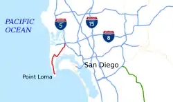
| Anfangspunkt: | beim Cabrillo National Monument |
| Endpunkt: | |
| County: | San Diego County |
Der 13 Kilometer lange Highway begann nahe dem Cabrillo National Monument im Stadtteil Point Loma von San Diego und endete nahe dem Kreuz der Interstate 5 mit der Interstate 8. Die State Route führte im Verlauf am Fort Rosecrans National Cemetery und westlich des San Diego International Airport vorbei.
Weblinks
Commons: California State Route 209 – Sammlung von Bildern, Videos und Audiodateien
- California Highways (englisch)
This article is issued from Wikipedia. The text is licensed under Creative Commons - Attribution - Sharealike. The authors of the article are listed here. Additional terms may apply for the media files, click on images to show image meta data.