California State Route 182
Die California State Route 182 (kurz CA 182) ist eine State Route im US-Bundesstaat Kalifornien, die in Süd-Nord-Richtung verläuft.
| ||||||||||
|---|---|---|---|---|---|---|---|---|---|---|
| Karte | ||||||||||
 | ||||||||||
| Basisdaten | ||||||||||
| Gesamtlänge: | 12,65 mi/20,36 km | |||||||||
| Anfangspunkt: | ||||||||||
| Endpunkt: | ||||||||||
| County: | Mono | |||||||||
|
Verlauf
| ||||||||||
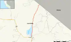
Die State Route beginnt am US Highway 395 in der Stadt Bridgeport. Von hier an wird sie auch als Sweet Water Road bezeichnet. Auf Ihrem Weg passiert sie den Bridgeport Lake und geht nach 12,5 Meilen an der Grenze zum Bundesstaat Nevada in die Nevada State Route 338 über.
Weblinks
Commons: California State Route 182 – Sammlung von Bildern, Videos und Audiodateien
- California @ AA Roads Streckenbeschreibung mit Fotos (englisch)
- California Highway
This article is issued from Wikipedia. The text is licensed under Creative Commons - Attribution - Sharealike. The authors of the article are listed here. Additional terms may apply for the media files, click on images to show image meta data.