California State Route 127
Die California State Route 127 (kurz CA 127) ist eine State Route im US-Bundesstaat Kalifornien. Sie verläuft teilweise durch den Death-Valley-Nationalpark.
| |||||||||||||||||||||||||||||||
|---|---|---|---|---|---|---|---|---|---|---|---|---|---|---|---|---|---|---|---|---|---|---|---|---|---|---|---|---|---|---|---|
| Karte | |||||||||||||||||||||||||||||||
 | |||||||||||||||||||||||||||||||
| Basisdaten | |||||||||||||||||||||||||||||||
| Gesamtlänge: | 90,89 mi/146,27 km | ||||||||||||||||||||||||||||||
| Anfangspunkt: | |||||||||||||||||||||||||||||||
| Endpunkt: | |||||||||||||||||||||||||||||||
| Countys: | San Bernardino County Inyo County | ||||||||||||||||||||||||||||||
| Wichtige Stadt: | Baker | ||||||||||||||||||||||||||||||
|
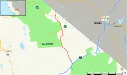
Verlauf
| |||||||||||||||||||||||||||||||
Der Highway beginnt am Interstate 15 in Baker und geht an der Grenze zu Nevada in die Nevada State Route 373 über.
Weblinks
- California @ AA Roads Streckenbeschreibung mit Fotos (englisch)
This article is issued from Wikipedia. The text is licensed under Creative Commons - Attribution - Sharealike. The authors of the article are listed here. Additional terms may apply for the media files, click on images to show image meta data.