Arizona State Route 78
Die Arizona State Route 78 ist eine State Route im US-Bundesstaat Arizona, die in Ost-West-Richtung verläuft.
| |
|---|---|
| Karte | |
 | |
| Basisdaten | |
| Gesamtlänge: | 19 mi/31 km |
| Anfangspunkt: | |
| Endpunkt: | |
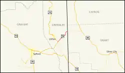
| County: | Greenlee County |
Die State Route beginnt an der Kreuzung mit dem U.S. Highway 191 und der Arizona State Route 75 nahe dem Greenlee County Airport in Three Way südlich von Clifton und endet östlich von Mule Creek an der Grenze zum Bundesstaat New Mexico. Nach der Grenze heißt der Highway New Mexico State Route 78.
Weblinks
Commons: Arizona State Route 78 – Sammlung von Bildern, Videos und Audiodateien
- Arizona Roads (englisch)
- AARoads (englisch)
This article is issued from Wikipedia. The text is licensed under Creative Commons - Attribution - Sharealike. The authors of the article are listed here. Additional terms may apply for the media files, click on images to show image meta data.