Arizona State Route 73
Die Arizona State Route 73 ist eine State Route im US-Bundesstaat Arizona, die in Ost-West-Richtung verläuft.
| |
|---|---|
| Karte | |
 | |
| Basisdaten | |
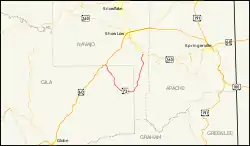
| Gesamtlänge: | 46 mi/75 km |
| Anfangspunkt: | |
| Endpunkt: | |
| Countys: | Navajo County Gila County |
Die State Route beginnt an der Arizona State Route 260 in Indiana Pine zwischen McNary und Pinetop-Lakeside und führt erst in Richtung Süden zum Fort Apache Indian Reservation nahe Whiteriver und von dort aus in Richtung Westen bis zum U.S. Highway 60 nahe Carrizo.
Ursprünglich führte die State Route 73 von San Carlos nach Springerville. Der südliche Teil bis San Carlos wurde stillgelegt und wird heute noch als Indian Route 9 aufrechterhalten. Der Abschnitt von McNary bis Springerville wurde ein Teil der State Route 260.
Weblinks
Commons: Arizona State Route 73 – Sammlung von Bildern, Videos und Audiodateien
This article is issued from Wikipedia. The text is licensed under Creative Commons - Attribution - Sharealike. The authors of the article are listed here. Additional terms may apply for the media files, click on images to show image meta data.