Arizona State Route 389
Die Arizona State Route 389 ist eine State Route im Norden des US-Bundesstaats Arizona.
| |
|---|---|
| Karte | |
 | |
| Basisdaten | |
| Gesamtlänge: | 32.60 mi/52.46 km |
| Anfangspunkt: | |
| Endpunkt: | |
| County: | Mohave County |
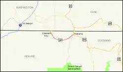
Sie erschließt den Arizona Strip, das durch den Grand Canyon vom Rest Arizonas abgetrennte nordwestlichste Stück des Bundesstaates.
Der Highway beginnt bei Colorado City an der Utah State Route 59 an der Grenze zu Utah, passiert die Kaibab Paiute Indian Reservation mit dem Pipe Spring National Monument und dem Ort Kaibab und endet nach der Überquerung des kleinen Kanab Creek am U.S. Highway 89A bei Fredonia.

State Route 389 in Mohave County
Weblinks
Commons: Arizona State Route 389 – Sammlung von Bildern, Videos und Audiodateien
- ArizonaRoads (englisch)
- AARoads (englisch)
This article is issued from Wikipedia. The text is licensed under Creative Commons - Attribution - Sharealike. The authors of the article are listed here. Additional terms may apply for the media files, click on images to show image meta data.