Arizona State Route 347
Die Arizona State Route 347 (kurz AZ 347) ist eine in Nord-Süd-Richtung verlaufende State Route im US-Bundesstaat Arizona.

| |
|---|---|
| Karte | |
 | |
| Basisdaten | |
| Gesamtlänge: | 28,5 mi/45,9 km |
| Anfangspunkt: | |
| Endpunkt: | |
| Countys: | Pinal County Maricopa County |
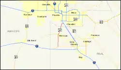
Die State Route beginnt an der Arizona State Route 84 westlich von Stanfield und endet nach 46 Kilometern nordwestlich von Sun Lakes an der Interstate 10.
Nach der Abzweigung von der AZ 84 verläuft die State Route 347 bis zur Stadt Maricopa in Richtung Norden. Innerhalb des Ortes zweigt die Arizona State Route 238 in westlicher Richtung ab und die AZ 347 führt anschließend in Richtung Nordosten. Sie endet nahe dem Gila River Memorial Airport an der Interstate 10
Weblinks
Commons: Arizona State Route 347 – Sammlung von Bildern, Videos und Audiodateien
- Arizona Roads (englisch)
- Rocky Mountain Roads (englisch)
This article is issued from Wikipedia. The text is licensed under Creative Commons - Attribution - Sharealike. The authors of the article are listed here. Additional terms may apply for the media files, click on images to show image meta data.