Arizona State Route 261
Die Arizona State Route 261 (kurz AZ 261) ist eine State Route im US-Bundesstaat Arizona, die in Nord-Süd-Richtung verläuft.
| |
|---|---|
| Karte | |
 | |
| Basisdaten | |
| Gesamtlänge: | 17,92 mi/28,84 km |
| Anfangspunkt: | |
| Endpunkt: | |
| County: | Apache County |
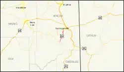
Die State Route beginnt an der Arizona State Route 273 am Crescent Lake und endet nach 29 Kilometern westlich von Eagar an der Arizona State Route 260. Nach etwa 16 Kilometern passiert die AZ 261 im Westen den Mexican Hay Lake. Die Straße verläuft durch den Apache-Sitgreaves National Forest und dient als Anbindung von Eagar und Springerville an die White Mountains sowie den Big Lake.
Weblinks
Commons: Arizona State Route 261 – Sammlung von Bildern, Videos und Audiodateien
This article is issued from Wikipedia. The text is licensed under Creative Commons - Attribution - Sharealike. The authors of the article are listed here. Additional terms may apply for the media files, click on images to show image meta data.