Aitov-Projektion
Die Aitov-Projektion ist eine 1889 von Dawid Alexandrowitsch Aitow vorgeschlagene Kartenprojektion.
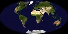
Aitov-Projektion
Dabei wird die Erdoberfläche auf einer Ellipse dargestellt. Die Darstellung ist nicht flächentreu, aber auf dem Äquator und dem zentralen Meridian längentreu.
Siehe auch
Weblinks
Commons: Aitov-Projektion – Sammlung von Bildern, Videos und Audiodateien
Nachweise
- John Parr Snyder: Flattening the Earth: Two Thousand Years of Map Projections. Chicago 1993, Seiten 130–133.
This article is issued from Wikipedia. The text is licensed under Creative Commons - Attribution - Sharealike. The authors of the article are listed here. Additional terms may apply for the media files, click on images to show image meta data.